CASE STUDY

Ecosystem services and Biodiversity Net Gain goals

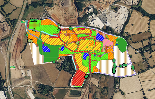
Discover how AiDASH helped National Grid transform its approach to biodiversity assessment and ESG reporting across more than 1,300 sites and 3,800 hectares of land. With ambitious ecosystem service improvement targets and regulatory pressure mounting, the traditional model of manual site surveys simply wasn’t scalable.

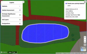
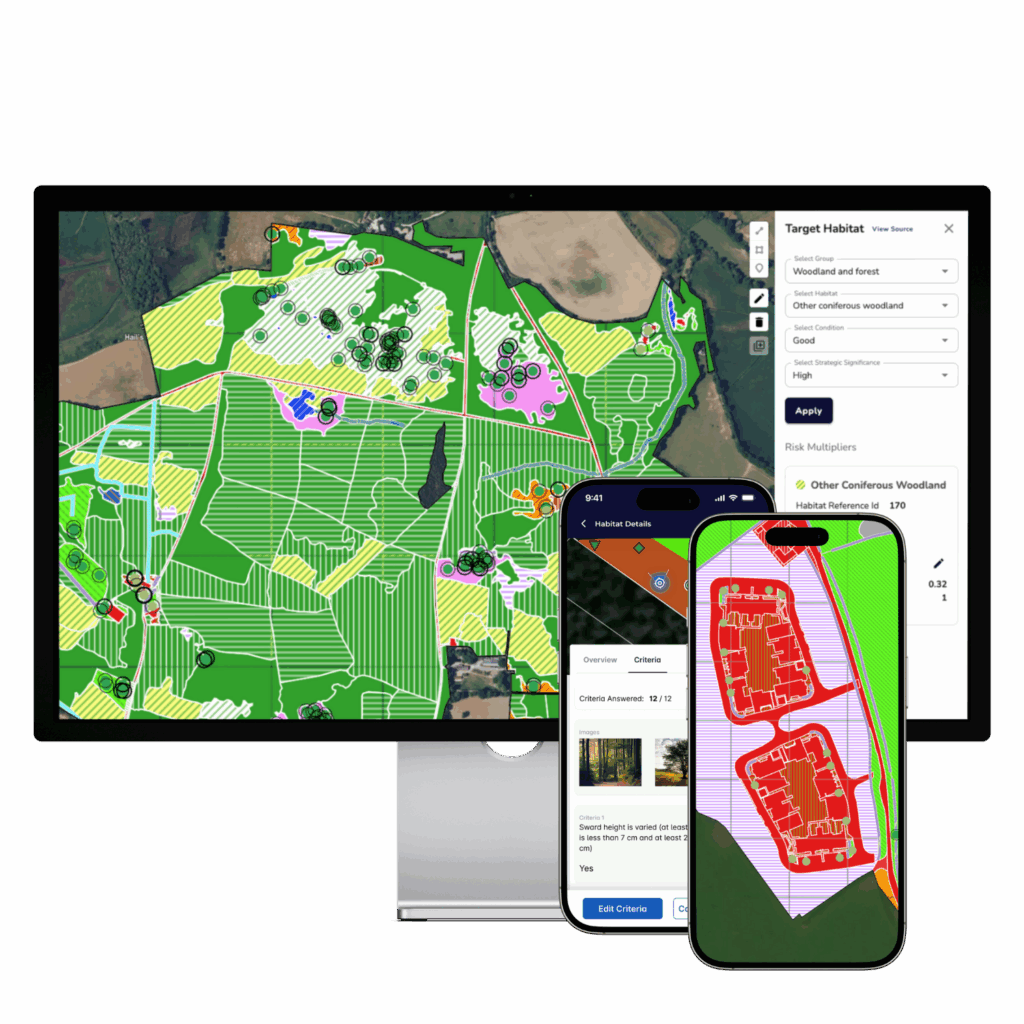
By deploying BNGAI™—an AI- and satellite-powered platform—National Grid unlocked a smarter, faster, and dramatically more cost-effective way to baseline habitats, plan sustainability interventions, and monitor long-term progress across its UK-wide estate.

Unlock the case study & learn how BNGAI™ transformed ecosystem services for National Grid.

Introduction

To meet its ambitious environmental targets, National Grid needed a smarter, faster way to understand, manage, and report on the biodiversity value of its landholding across the UK. From rural substations to roadside telecoms towers, the estate spans over 1,300 unique locations and 3,800 hectares, making it one of the most distributed infrastructure land portfolios in the country.

With 2030 targets in sight—including a commitment to enhance ecosystem services by 10–14%—National Grid turned to a digital-first solution to baseline habitats, inform sustainability planning, and monitor environmental progress across its entire estate.

THE CHALLENGE

Insight at scale

Traditional survey methods were never designed for portfolios of this size. National Grid’s estate stretches across England, Scotland, and Wales, encompassing everything from operational substations to buffer zones and access corridors. Each site presents its own ecological context, risks, and opportunities.

But attempting to survey 1,300+ locations manually—at a cost of £750 to £5,000 per site—was unfeasible. Not only would it require a vast budget, but the timeline to assess every site would stretch over years. And as environmental pressures grow and regulatory expectations evolve, delayed insight means delayed action.

The team needed a new way to work: one that could deliver repeatable, portfolio-wide insights—accurately, affordably, and aligned with UK biodiversity and ESG standards.

Screenshot from the BNGAI™ platform on an external project’s habitat condition assessment

THE SOLUTION

Automated insight, measurable impact

To overcome the scale and cost barriers of manual surveying, National Grid partnered with AiDASH to roll out its Intelligent Sustainability Management System—the original version of what is now BNGAI™—across its entire UK estate.

This AI-powered, satellite-enabled platform enabled National Grid to automate biodiversity assessments and generate verifiable habitat baselines across over 1,300 diverse sites, all without setting foot on the ground. The platform also supported sustainability planning, delivery tracking, and ESG reporting, with outputs fully aligned to UK environmental standards, including those set by Defra and Natural England.

The results were transformative. By replacing manual surveys with remote, repeatable assessments, the platform delivered cost savings of 15x to 100x per site—while also improving the consistency, quality, and geographic coverage of ecological data across a highly variable land portfolio.

This approach didn’t just accelerate reporting—it fundamentally changed how National Grid plans and manages its environmental strategy at scale.

10-14%

BNG commitment

1.341

unique sites

£750–£5,000

cost of manual survey per site

15–100x

cost savings delivered by BNGAI™

Services provided

From data to decisions

The BNGAI™ platform was deployed across all National Grid and National Grid Telecoms (NGT) sites in the UK, covering a total habitat area of nearly 3,900 hectares. The deployment included:

1. UK-wide habitat classification

Automated assessments across 1,300+ unique sites, using satellite data and AI to identify habitat types and boundaries with precision.

2. Portfolio-wide sustainability reporting

Aggregated insights across the estate enabled clear visibility into habitat condition, risk areas, and opportunities for biodiversity enhancement.

3. Defra and Natural England compliance support

All outputs aligned with Statutory Biodiversity Metric and UKHab standards, ensuring compatibility with BNG, regulatory reporting, and internal ESG targets.

4. Custom configuration

The platform was tailored to reflect the needs of different regional teams and business units, supporting everything from strategic planning to local action.

5. Ongoing ESG and biodiversity monitoring

Dashboards and analytics helped track progress over time, measure impact, and plan for future interventions.

6. Dedicated reporting views

Separate dashboards were developed for both National Grid (NG) and National Grid Telecoms (NGT) portfolios, enabling focused decision-making.

Geographic coverage

While England accounted for the majority of sites and land area, AiDASH’s platform was deployed across all three nations:

  • England – 84% of total land area

    3,272 hectares across 1,127 sites

  • Scotland – 12.6% of total land area

    490 hectares across 131 sites

  • Wales – 3.1% of total land area

    121 hectares across 83 sites

The nationwide rollout ensured consistent methodology, standardised outputs, and comparable results across the UK—enabling National Grid to track progress both nationally and regionally.


Key benefits

Scalable insight across 3,800+ hectares

Automates assessment and analysis across large, distributed estates without the need for physical site visits.

Up to 100x cost savings

Compared to conventional surveys, the digital method delivers significant savings—unlocking budget for action, not just assessment.

Supports national and regional targets

Enables tailored reporting and planning for biodiversity gains in England, Scotland, and Wales.

Verifiable and regulator-ready

Outputs align with UK statutory frameworks, ensuring trust and credibility in both internal and external reporting.

Fully repeatable for long-term tracking

Enables consistent year-on-year monitoring of biodiversity and ESG performance across the entire estate.

Comprehensive platform for data-driven decisions

Consolidates biodiversity and ESG insights in one place to support informed, strategic planning at every level.

See how BNGAI™ can scale your biodiversity insight

Get a demo and explore how remote sensing and AI can support your environmental goals.